Your field journal NW SOUTH AMERICA · EQUATOR 0°00′00″

Ecuador: An adventure from coast to clouds

Welcome to Ecuador! Journey from sunny Pacific beaches and volcanic islands up to snowy Andean peaks and lush Amazon rainforests.

Location
Northwestern South America
Capital City
Quito (0.18°S, 78.47°W)
Four Regions
Coast · Inter-Andean · Amazon · Galápagos
Highest Peak in Ecuador
Mount Chimborazo (~6,263 m / 20,548 ft)
ES Resumen en Español / Spanish Overview & Key Terms

Ecuador en América del Sur: Ecuador está ubicado en el noroeste de América del Sur (Northwestern South America), atravesado por la línea ecuatorial. Su capital es Quito.

El país se divide en cuatro regiones geográficas: La Costa (Coast, junto al océano Pacífico al oeste), La Sierra o Región Interandina (Inter-Andean / Highlands, atravesada por la Cordillera de los Andes), La Amazonía (Amazon, selva tropical al este) y Galápagos o Región Insular (archipiélago volcánico en el océano Pacífico).

A wild light-brown vicuña standing on the high Andean páramo grassland in the foreground, with the snow-covered volcanic peak of Mount Chimborazo rising against a blue sky in the background.
Field Plate I: A wild Andean vicuña (Vicugna vicugna) grazing on the high-altitude páramo before the glacier-capped summit of Mount Chimborazo in Ecuador's Inter-Andean Sierra.
Photograph: David Torres Costales · Licensed under CC BY-SA 3.0 via Wikimedia Commons (resized and re-encoded to WebP).
CHAPTER 01 CARTOGRAPHY & REGIONS

Find Ecuador

Ecuador sits on the equator in northwestern South America, right along the Pacific Ocean. Its capital city is Quito. The country has four amazing natural regions to explore: Coast, Inter-Andean (Sierra), Amazon, and Galápagos.

GEOGRAPHY NOTE
One mountain region: Remember that Inter-Andean, Sierra, and Highlands all mean the same central mountain region—Ecuador has four regions total, not five! Map markers show helpful learning locations on public-domain Natural Earth data.
PLATE II-A · CONTINENTAL CONTEXT

South America (13 Natural Earth Features)

Map of South America highlighting Ecuador in the northwest Geographic map rendered from Natural Earth 1:50m data showing all 13 South American territories, the Equator line at 0 degrees latitude, and Ecuador highlighted in northwestern South America with its capital Quito.

Click or press Enter on Ecuador (ECU) in northwestern South America to focus the continental overview.

PLATE II-B · ECUADOR & GALÁPAGOS INSET

Four Regions, Quito (-78.47°, -0.18°) & Chimborazo

Detailed map of Ecuador with Galápagos Islands inset and four regional reference markers Interactive geographic map of mainland Ecuador and an inset box for the Galápagos Islands in the Pacific Ocean. Shows Quito at -78.47, -0.18, Mount Chimborazo, and approximate point markers for the Coast, Inter-Andean Sierra, Amazon, and Galápagos regions.

Map Reference Key:

  • ★ Quito: Capital City (0.18°S, 78.47°W)
  • ▲ Mount Chimborazo: Highest Andean peak (~6,263 m)
  • ● 1 Coast (La Costa): Western Pacific lowlands
  • ▲ 2 Inter-Andean (La Sierra): Central Andes highlands
  • ◆ 3 Amazon (La Amazonía): Eastern rainforest basin
  • ⬡ 4 Galápagos: Volcanic archipelago (~1,000 km W)

Cartographic note: Regional points (1–4) are approximate educational anchors, NOT official regional boundaries. Galápagos inset is shown at a separate scale (~1,000 km west in the Pacific Ocean). Data source: Natural Earth 1:50m Admin-0 Countries (Public Domain).

TARGET: ECUADOR OVERVIEW 01°28′N TO 05°00′S · 75°15′W TO 91°40′W

Ecuador in Northwestern South America

República del Ecuador — Cuatro Regiones Naturales y Capital Quito

Ecuador is located in northwestern South America along the Pacific Ocean. The Equator passes right through the country, giving Ecuador its name! Rising from ocean beaches to snowy Andean peaks, Ecuador has four unique regions.

Síntesis en español: Ecuador se sitúa en el noroeste de América del Sur. Su capital es Quito y su territorio comprende cuatro regiones: La Costa (oeste), La Sierra o Región Interandina (centro andino), La Amazonía (este) y las Islas Galápagos o Región Insular (en el océano Pacífico).
Geographic Position
Northwestern South America (Pacific Rim & Equator)
Key Landforms
Coastal plains, Andean cordillera & valleys, Amazon basin, volcanic islands
Climate & Ecosystems
Varies strongly by altitude and ocean currents rather than four temperate seasons
Classroom Study Key
Capital: Quito · 4 Regions: Coast, Inter-Andean (Sierra), Amazon, Galápagos

Four regions included

REGION 01 · WEST

Coast (La Costa)

The Coast lies along the western mainland next to the Pacific Ocean. It has warm sandy beaches, lowlands, and big port cities like Guayaquil.

En español: Ubicada al oeste junto al océano Pacífico; llanuras costeras, playas y tierras agrícolas fértiles.

REGION 02 · CENTRAL BELT

Inter-Andean (La Sierra / Andes)

The Inter-Andean region is the central mountain backbone of Ecuador. It contains the towering Andes Mountains, fertile valleys, the capital city Quito, and giant volcanoes like Chimborazo.

En español: Una sola región central andina (llamada Interandina o Sierra) con montañas, volcanes, valles, tierras altas y la capital, Quito.

REGION 03 · EAST

Amazon (La Amazonía / El Oriente)

The Amazon region lies east of the Andes mountains. It is covered in warm tropical rainforests and wide winding rivers that flow toward the Amazon River.

En español: Situada al este de los Andes; bosques húmedos tropicales y grandes ríos de la cuenca amazónica.

REGION 04 · PACIFIC OCEAN (~1,000 KM WEST)

Galápagos (Región Insular)

The Galápagos Islands are a volcanic archipelago in the Pacific Ocean about 1,000 km west of the mainland. They are famous for giant tortoises, swimming marine iguanas, and unique wildlife.

En español: Archipiélago de islas de origen volcánico en el océano Pacífico, al oeste del continente.

CHAPTER 02 GEOMORPHOLOGY & ELEVATION

Meet the Andes

The Andes Mountains rise high above Ecuador like a giant spine. As you travel from the coast to the mountains, you discover four important landforms: mountain ranges, volcanoes, valleys, and highlands.

PLATE III · TOPOGRAPHIC TRANSECT SCHEMATIC (WEST TO EAST) ILLUSTRATIVE PROFILE · NOT TO SCALE
Cross-section profile of Ecuador from the Pacific Coast across the Andes Mountains, Valleys, and Highlands to the Amazon Basin Diagram showing how elevation rises from the Pacific Ocean and Coast in the west to the Western and Eastern Cordilleras of the Andes Mountains, with a high-elevation Inter-Andean valley and highlands between peaks, and Mount Chimborazo volcano reaching approximately 6,263 meters, before descending east into the Amazon rainforest. ~6,263 m (20,548 ft) — Chimborazo Summit ~2,800–4,200 m — Andean Highlands 0 m — Sea Level (Pacific Ocean) GALÁPAGOS ~1,000 km W 1. COAST Western lowlands CHIMBORAZO (VOLCANO) VALLEYS & HIGHLANDS Low area between peaks 2. ANDES MOUNTAINS Inter-Andean / La Sierra 3. AMAZON Eastern rainforest basin

Topographic Profile Key (West to East):

  • Pacific Ocean & Coast: Sea-level coastal lowlands in the west. (Galápagos lies ~1,000 km west).
  • Mount Chimborazo (~6,263 m): Giant volcano and highest peak in Ecuador.
  • Inter-Andean Valleys & Highlands (~2,800–4,200 m): Páramo grasslands and fertile valleys where Quito sits (~2,850 m).
  • Andes Mountains (Sierra): High mountain cordillera; not every mountain is an active volcano.
  • Amazon Basin: Eastern slopes descending into tropical rainforest.
Schematic Cross-Section: How Ecuador's landforms transition from the western Pacific Coast across the Andes Mountains (including high plateaus/highlands, inter-Andean valleys, and volcanic peaks) to the eastern Amazon basin.
TERM 01 · MOUNTAIN RANGE

Andes Mountains (Cordillera de los Andes)

Classroom Study Definition: “Large mountain ranges.”

The Andes form a giant mountain range running down western South America. Many volcanoes rise here, but not every mountain is a volcano!

More science detail

Many mountains form through tectonic folding and uplift of Earth's crust without an eruptive vent. The Andes stretch over 7,000 km across seven South American countries.

En español: Gran cadena montañosa que recorre el oeste de Sudamérica y atraviesa el centro del Ecuador. No toda montaña es un volcán.

TERM 02 · CRUSTAL OPENING

Volcanoes (Volcanes)

Classroom Study Definition: “Openings in the Earth's crust that can release lava.”

A volcano is an opening in Earth's crust where melted rock, ash, and gases can escape. Over repeated eruptions, the escaping materials build a cone-shaped mountain around the opening.

More science detail

Volcanoes form along plate boundaries and hot spots where magma rises from Earth's mantle through the crust.

En español: Aberturas en la corteza terrestre por donde pueden salir lava, ceniza volcánica, fragmentos de roca y gases, así como la montaña formada a su alrededor.

TERM 03 · INTER-MOUNTAIN BASIN

Valleys (Valles)

Classroom Study Definition: “Low areas between mountains.”

A valley is a low area of land between hills or mountains, often carved by rivers. In the Andes, sheltered valleys have milder weather and rich volcanic soil where cities like Quito thrive.

More science detail

Inter-Andean valleys are cradled between the Western and Eastern Cordilleras, creating natural corridors for communities and agriculture.

En español: Áreas bajas situadas entre colinas o cadenas montañosas, frecuentemente recorridas por ríos.

TERM 04 · ELEVATED TERRAIN

Highlands (Tierras Altas / Altiplano y Páramo)

Classroom Study Definition: “High areas between mountains.”

Highlands are broad areas of elevated land between mountains, such as plateaus and chilly páramo grasslands. They are much wider than a single mountain peak and have cooler air than the lowlands.

More science detail

Andean highlands act like natural water towers, gathering moisture from clouds to feed rivers across Ecuador.

En español: Regiones amplias de terreno elevado (como mesetas y páramos entre cordilleras), distintas de una sola cima aislada.

CHAPTER 03 READING PASSAGE & SCIENTIFIC REVIEW

The giant Chimborazo

Read the classroom passage below to learn about Ecuador's highest mountain. Then check the science notes to see what volcanologists and space scientists have discovered!

ACCORDING TO THE TEACHER'S READING CLASSROOM TEXT REFERENCE

The Giant Chimborazo

Chimborazo is a giant volcano in the Andes Mountains of Ecuador. According to our classroom reading, it stands approximately 6,263 meters (20,548 feet) high, making it the highest mountain in all of Ecuador.

Chimborazo holds a remarkable geographic distinction. Even though Mount Everest is higher above sea level, Chimborazo's summit is the point on Earth's surface farthest from Earth's center (often described in classroom stories as pushing farthest outward because Earth is wider in the middle around the Equator).

How did Chimborazo get its name? People are not 100% sure, and the exact origin is uncertain. The classroom reading shares one local story suggesting that “Chimbu” might mean “on the other side” and “razor” or “ruco” might mean “ice” or “snow”—like saying “the mountain of ice.”

At its summit, Chimborazo is covered in white snow and glacial ice, and its high slopes are home to slender, woolly Andean animals called vicuñas.

READING WORDING TO EXAMINE: The classroom handout uses the everyday word “inactive” to describe Chimborazo today—read the Science Note directly beside this passage to see why volcanologists classify Chimborazo as potentially active and why “inactive” never means guaranteed safe.

ES Traducción de la Lectura al Español / Spanish Passage Translation

El gigante Chimborazo (Según la lectura escolar): El Chimborazo es un gran volcán en los Andes del Ecuador. Según la lectura de clase, mide aproximadamente 6.263 metros (20.548 pies) de altura, siendo la montaña más alta del Ecuador.

Aunque el Monte Everest tiene mayor altitud sobre el nivel del mar, la cumbre del Chimborazo es el punto de la superficie terrestre más alejado del centro de la Tierra debido a que la Tierra se ensancha en el ecuador.

Origen del nombre (incierto): No se conoce con certeza el origen exacto de su nombre; la lectura menciona un relato según el cual podría significar «montaña de hielo o nieve», pero existen varias hipótesis lingüísticas. Su cima está cubierta de nieve y hielo glaciar, y en sus laderas habitan las vicuñas.

Nota importante sobre «inactivo»: La lectura escolar usa la palabra «inactive», pero el Instituto Geofísico (IG-EPN) clasifica al Chimborazo como potencialmente activo. Que no esté en erupción ahora no significa que sea seguro ni que nunca pueda volver a erupcionar.
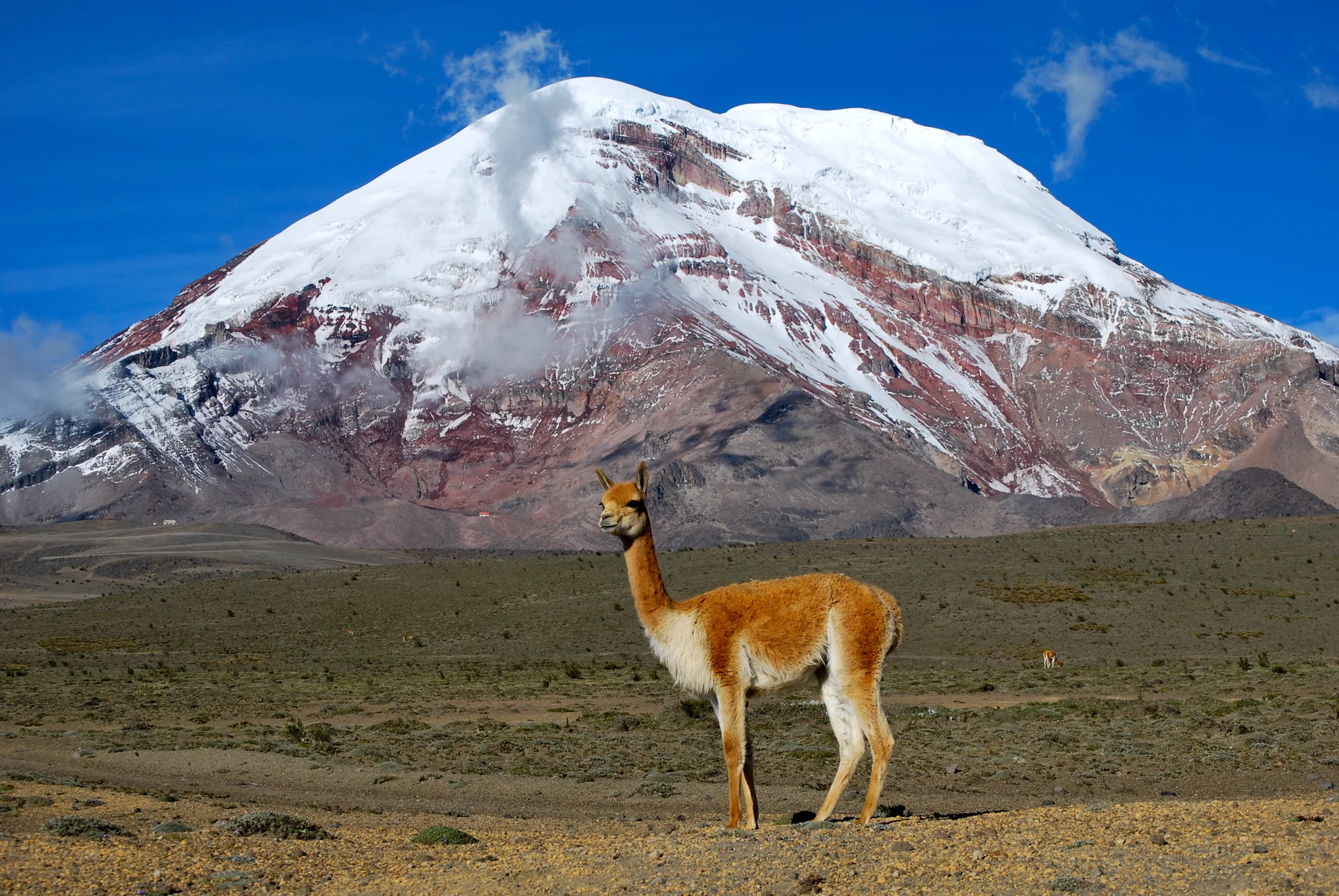
PLATE IV · GEODETIC COMPARISON (NOAA / IG-EPN) NOT TO SCALE · EARTH'S EQUATORIAL BULGE EXAGGERATED FOR CLARITY
Diagram comparing distance from Earth's center vs. height above sea level for Mount Chimborazo and Mount Everest Schematic diagram labeled Not to scale; Earth's bulge is exaggerated. Shows a dashed circle for a hypothetical spherical Earth and an ellipse bulging wider at the Equator. Chimborazo sits near the Equator at 1.47 degrees South, making its peak 6,384.4 km from Earth's center, farther than Mount Everest at 28 degrees North (6,382.3 km from Earth's center), even though Everest is higher above sea level. EARTH'S CENTER EQUATOR (0° LATITUDE) MOUNT EVEREST (28°N) Highest above sea level: 8,848 m From Earth's center: ~6,382.3 km CHIMBORAZO (1.47°S) Reading height: ~6,263 m (20,548 ft) From Earth's center: ~6,384.4 km FARTHEST FROM EARTH'S CENTER Note: Diagram not to scale; Earth's equatorial bulge is exaggerated to illustrate the two reference systems.

Two Different Ways to Measure a Mountain

Measurement Reference Mount Chimborazo (Ecuador) Mount Everest (Himalayas)
Height Above Sea Level ~6,263 m (20,548 ft) (Teacher's reading figure; highest in Ecuador) 8,848 m (World's highest above sea level)
Distance from Earth's Center ~6,384.4 km (World's farthest summit from Earth's center) ~6,382.3 km (~2.1 km closer to center than Chimborazo)
Latitude Position ~1°28′S (Right on the Equatorial Bulge) ~27°59′N (North of the tropics)
CHAPTER 04 VOLCANOLOGY & 6-PART INTERIOR CUTAWAY

Look inside a volcano

Discover how volcanoes work! Learn the three volcanic states—active, dormant, and extinct—and explore the cutaway model to inspect all six parts inside.

STATE 01 · ACTIVE

Active Volcano (Volcán Activo)

Classroom Study Summary: “When the volcano has activity, lava, ash, etc.”

Scientific Meaning (USGS / NPS): An active volcano is currently erupting or shows signs of unrest like earthquakes and escaping gas. In Ecuador, volcanoes like Sangay and Reventador erupt frequently.

More science detail

Scientists monitor ground swelling, volcanic tremors, and thermal anomalies to track active volcanoes in real time.

En español: Volcán que presenta actividad eruptiva actual, señales sísmicas o de gases, o erupciones en el pasado geológico reciente.

STATE 02 · DORMANT / POTENTIALLY ACTIVE

Dormant Volcano (Durmiente / Potencialmente Activo)

Classroom Study Summary: “When the volcano may erupt in the future.”

Scientific Meaning (USGS / IG-EPN): A dormant volcano is sleeping and quiet right now, but it is capable of erupting again in the future. Scientists describe these as potentially active—just like Mount Chimborazo!

More science detail

Dormant volcanoes still retain magma supplies or magma generating systems beneath the crust, even if quiet for centuries.

En español: Volcán que no está en erupción ahora pero puede volver a erupcionar en el futuro (como el Chimborazo según el IG-EPN).

STATE 03 · EXTINCT

Extinct Volcano (Volcán Extinto)

Classroom Study Summary: “When the volcano won't erupt in the future.”

Scientific Meaning (USGS / NPS): An extinct volcano has completely run out of magma and is not expected to erupt ever again. Geologists study rock layers and magma supplies to confirm a volcano has shut down permanently.

More science detail

Classifications can be updated if new deep seismic activity is discovered, but extinct volcanoes show no active volcanic processes.

En español: Volcán que ya no tiene suministro de magma y que, según la evidencia científica, no se espera que vuelva a erupcionar.

OPTIONAL FIELD HYPOTHESIS · NEVER GRADED OR SCORED

Before You Explore: Magma vs. Lava

Both magma and lava are super-hot melted rock! What do you predict changes magma into lava? Pick any hypothesis below or skip straight to the interactive cutaway—guesses are never graded.

GENERIC TEACHING MODEL — SCHEMATIC NOT TO SCALE Does not depict Chimborazo's actual interior and does not represent a currently erupting Chimborazo.
Cross-section schematic of a stratovolcano showing six distinct parts Generic volcano cutaway model showing the underground magma chamber beneath Earth's surface, the central conduit rising to the central vent and bowl-shaped summit crater, a side vent opening on the right flank, lava flowing down the exterior left slope, and an ash plume rising into the air from the summit vent. ORIGINAL GROUND SURFACE LEVEL UNDERGROUND CRUST (SUBSURFACE) 5. ASH (Ceniza Volcánica) 2. CRATER (Cráter) 1. LAVA (Surface Flow) 4. CENTRAL VENT & CONDUIT 6. SIDE VENT (Flank Vent) 3. MAGMA (Underground)

Interactive model ready

SELECT ANY OF THE 6 VOLCANO PARTS

Six Parts of a Volcano

SELECTED PART 01 OF 06 · SURFACE

Lava (Lava)

Definition (USGS / NPS): Molten rock (magma) that has broken through a volcanic vent and reached Earth's exterior surface, flowing down the slopes of the volcano before cooling and solidifying into volcanic rock.

Key Distinction: Do not confuse lava with underground magma (which is still beneath the ground) or with volcanic ash clouds.

En español: Roca fundida que ya ha alcanzado la superficie terrestre y fluye por las laderas externas del volcán.

All six volcano parts reference catalogue (Click to expand)

1. Lava (Lava)

Where it is: Outside the volcano, flowing on Earth's surface.

What it is: Magma that has reached Earth's surface through a central or side vent. As lava flows down the exterior flank and cools, it hardens into solid rock layers.

2. Crater (Cráter)

Where it is: At the summit (top) of the volcanic cone.

What it is: A bowl-shaped or funnel-shaped depression at the top of a volcano, usually surrounding the main central vent opening.

3. Magma (Magma / Cámara magmática)

Where it is: Deep underground, beneath Earth's surface.

What it is: Extremely hot molten (melted) rock, dissolved gases, and crystals stored below ground in the magma reservoir before reaching the surface.

4. Central Vent & Conduit (Abertura y conducto central)

Where it is: Center of the volcano connecting the underground chamber to the summit.

What it is: The main vertical underground conduit (pipe) carrying magma upward, and the central opening at the summit where volcanic material exits.

5. Ash (Ceniza volcánica)

Where it is: Ejected from a volcanic vent into the sky and settling over the landscape.

What it is: Fine particles of pulverized volcanic rock, minerals, and volcanic glass (under 2 mm across) blasted out during an eruption—not soft smoke from burning wood.

6. Side Vent (Abertura o cono lateral)

Where it is: Breaking out to an opening on the outside flank (side slope) of the volcano.

What it is: A secondary opening on the side or flank of a volcano where a branching underground passage reaches the exterior surface and releases lava or gas.

CHAPTER 05 EARTH HAZARDS & RECOGNITION

When nature changes

Earth is an active planet! Learn how scientists define five powerful natural events—earthquakes, wildfires, droughts, tsunamis, and tornadoes—and how to stay prepared.

PREPAREDNESS NOTE
Learning to stay safe: Studying how Earth works helps us understand powerful natural events and stay prepared. If an emergency happens, always listen carefully to trusted adults and local safety helpers.
PHENOMENON 01 · TECTONIC FAULT MOVEMENT

Earthquake (Terremoto / Sismo)

Definition (USGS): A sudden shaking of the ground caused by rocks slipping along an underground fault in Earth's crust.

Keep in mind: Earthquakes come from underground rock movement, not weather storms!

Safety habit & scenario
Safety habit: Practice Drop, Cover, and Hold On under a sturdy desk or table, staying away from windows.

En español: Sacudida repentina del suelo causada comúnmente por el movimiento de rocas a lo largo de una falla geológica. Práctica básica: Agacharse, Cubrirse y Sujetarse lejos de ventanas.

PHENOMENON 02 · UNCONTROLLED VEGETATION FIRE

Wildfire (Incendio Forestal / de Vegetación)

Definition: An uncontrolled fire that spreads quickly across dry grass, brush, or forest trees.

Keep in mind: Wildfires can start from lightning, but many are started accidentally by humans.

Safety habit & scenario
Safety habit: Never play with fire, and evacuate right away with trusted adults if officials issue an alert.

En español: Incendio no planificado que se propaga sin control a través de la vegetación natural (bosques, pastizales o matorrales).

PHENOMENON 03 · PERSISTENT WATER DEFICIT

Drought (Sequía)

Definition (NOAA): A long period of dry weather with much less water or rain than normal.

Keep in mind: A single sunny afternoon is not a drought! Droughts develop over weeks, months, or years.

Safety habit & scenario
Safety habit: Conserve water every day and help protect mountain watersheds like the Andean páramo.

En español: Período prolongado con muy poca agua disponible (frecuentemente por lluvias muy inferiores a lo habitual) que perjudica a las personas, plantas o animales; no es simplemente una tarde sin lluvia.

PHENOMENON 04 · OCEAN WATER DISPLACEMENT

Tsunami (Tsunami / Maremoto)

Definition (NOAA): A series of giant ocean waves caused by underwater earthquakes, landslides, or volcanic eruptions.

Keep in mind: A tsunami is a series of waves over several hours, not just one wave or a tidal change!

Safety habit & scenario
Safety habit: If you feel strong shaking at the coast or see ocean water pull back, move uphill to high ground immediately.

En español: Serie de olas oceánicas causadas por el desplazamiento repentino de un gran volumen de agua (a menudo por un sismo submarino). No es una sola ola ni es causada por las mareas.

PHENOMENON 05 · ROTATING THUNDERSTORM VORTEX

Tornado (Tornado)

Definition (NOAA NSSL): A violently spinning funnel of wind that stretches from a thunderstorm cloud all the way to the ground.

Keep in mind: A small dust swirl on a sunny day is not a tornado—a real tornado must connect to a thunderstorm cloud!

Safety habit & scenario
Safety habit: Go to a basement or an inside room on the lowest floor, far away from windows.

En español: Columna de aire que gira violentamente y se extiende desde una tormenta eléctrica hasta tocar el suelo.

CHAPTER 07 FIELD VERIFICATION · 30 QUESTIONS

Try your field checks

Test your knowledge with 30 fun questions! You can practice one question at a time or see all questions together, with helpful hints whenever you need them.

UNIQUE QUESTIONS MASTERED
0 / 30 (Repeats never inflate score · Stored locally only)